
1941 Map of Bradford
USGS Topo · Published 1958About this map
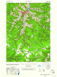
Bradford and its surrounding valleys are defined by an intricate network of rail lines and industrial infrastructure just before the mid-century, reflecting the region's legacy of oil and timber extraction. The map details the convergence of the Erie RR and the Baltimore and Ohio RR, which serviced smaller upland settlements like Degolia, Custer City, and Lewis Run. Notable for genealogists are the numerous rural educational sites including Bolivar Run Sch and Songbird Sch, alongside specialized post offices such as Cyclone PO and Davis Gifford PO. The landscape is etched with the names of local landmarks like Hedgehog Hollow, Wildcat Ridge, and Cherry Hill, while the water supply for the growing city is secured through a series of numbered reservoirs including Reservoir No 1. The southern portion of the sheet reveals the complex industrial junctions at Crawford Junction and the small communities of Mount Alton and Kushequa.
Find a feature on this map
80 named features on this map. Tap any name to fly to it.
Don’t see what you’re looking for? This feature index may not catch every label — zoom into the map to look around manually.
Map Details
Editions of this 1941 Bradford Map
2 editions found
Other maps of this area

1898 · Olean
USGS Topo · 1:62,500

1900 · Salamanca
USGS Topo · 1:62,500

1922 · Randolph
USGS Topo · 1:62,500

1923 · Randolph
USGS Topo · 1:62,500

1924 · Bradford
USGS Topo · 1:62,500

1926 · Bradford
USGS Topo · 1:62,500

1933 · Smethport
USGS Topo · 1:62,500

1934 · Kane
USGS Topo · 1:48,000

1935 · Mt. Jewett
USGS Topo · 1:48,000

1936 · Kinzua
USGS Topo · 1:48,000