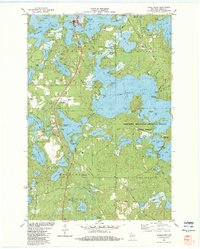
1982 Map of Hazelhurst
USGS Topo · Published 1983About this map
Minocqua and Hazelhurst anchor this detailed study of the Northwoods lake country in the early 1980s. The landscape is defined by an intricate network of waterways, from the expansive Tomahawk Lake and Minocqua Lake to smaller basins like Katherine Lake and Blue Lake. The presence of the Bearskin State Park Trail, following the path of an Abandoned Railroad, illustrates the transition of former industrial corridors into recreational assets.
Find a feature on this map
108 named features on this map. Tap any name to fly to it.
Don’t see what you’re looking for? This feature index may not catch every label — zoom into the map to look around manually.
Map Details
Editions of this 1982 Hazelhurst Map
This is the sole edition of this map. No revisions or reprints were ever made.
Other maps of this area

1938 · Minocqua
USGS Topo · 1:48,000

1938 · Lac Du Flambeau
USGS Topo · 1:48,000

1939 · Lac Du Flambeau
USGS Topo · 1:48,000

1939 · Mc Cord
USGS Topo · 1:48,000

1939 · Cassian
USGS Topo · 1:48,000

1942 · Cassian
USGS Topo · 1:48,000

1946 · Minocqua
USGS Topo · 1:48,000

1946 · Lac Du Flambeau
USGS Topo · 1:48,000

1947 · Mc Cord
USGS Topo · 1:48,000

1949 · Minocqua
USGS Topo · 1:48,000