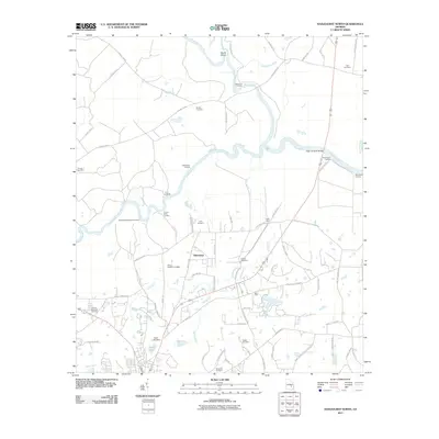
2011 Map of Hazlehurst North
USGS Topo · Published 2011About this map
The confluence of the Ocmulgee River and Oconee River defines this South Georgia landscape, where they merge to form the Altamaha River. This riverine system was historically vital for transport and trade, evidenced by the numerous landings dotting the banks, such as Town Bluff Landing, Round Bluff Landing, and McEachins Woodyard Landing. The settlement of Tallahassee sits centrally within the quadrangle, surrounded by a network of rural roads like Towns Bluff Rd and Philadelphia Methodist Church Rd. For genealogists, the map is a significant resource, documenting several family-named burial grounds including the Mobley Cemetery, Hester Cemetery, and McEachin Cemetery. The presence of Halls Spur indicates the area's logistical history, while modern landmarks like the Neel Lee Gillis Bridge connect the river-separated counties.
Find a feature on this map
78 named features on this map. Tap any name to fly to it.
Don’t see what you’re looking for? This feature index may not catch every label — zoom into the map to look around manually.
Map Details
Editions of this 2011 Hazlehurst North Map
This is the sole edition of this map. No revisions or reprints were ever made.
Other maps of this area

1953 · Waycross
USGS Topo · 1:250,000

1957 · Macon
USGS Topo · 1:250,000

1958 · Macon
USGS Topo · 1:250,000

1958 · Waycross
USGS Topo · 1:250,000

1964 · Macon
USGS Topo · 1:250,000

1970 · Alston
USGS Topo · 1:24,000

1970 · Uvalda
USGS Topo · 1:24,000

1970 · Jordan
USGS Topo · 1:24,000

1970 · Pine Grove
USGS Topo · 1:24,000
1970 · Grays Landing
USGS Topo · 1:24,000