1970 Map of Jordan
USGS Topo · Published 1973About this map
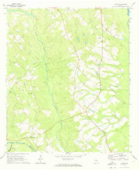
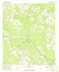
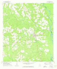
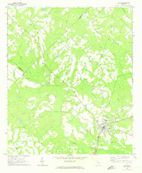
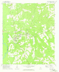
The small community of Jordan and the nearby settlement of Spring Hill anchor this rural landscape in Wheeler County, surveyed at the end of the 1960s. The area is defined by its numerous small congregational hubs, such as Sardis Ch, Hope Ch, and Shiloh Ch, which reflect the localized social structure of mid-century Georgia. Geologic and infrastructure features include a Gaging Station and a major utility Pipeline that traverses the terrain. The southern border of the quadrangle follows the Little Ocmulgee River and the Southern railroad line, marking a clear divide between Wheeler and Telfair Counties. Multiple family-named cemeteries, including Adams Cem and Benton Cem, are scattered across the network of rural roads, providing valuable reference points for genealogists researching the families of the Oconee river basin.
Find a feature on this map
28 named features on this map. Tap any name to fly to it.
Don’t see what you’re looking for? This feature index may not catch every label — zoom into the map to look around manually.
Map Details
Editions of this 1970 Jordan Map
This is the sole edition of this map. No revisions or reprints were ever made.
Other maps of this area

1953 · Waycross
USGS Topo · 1:250,000

1957 · Macon
USGS Topo · 1:250,000

1958 · Macon
USGS Topo · 1:250,000

1958 · Waycross
USGS Topo · 1:250,000

1964 · Macon
USGS Topo · 1:250,000
1970 · Scotland
USGS Topo · 1:24,000
1970 · Glenwood
USGS Topo · 1:24,000
1970 · Alamo
USGS Topo · 1:24,000
1970 · Mount Vernon
USGS Topo · 1:24,000
1970 · Uvalda
USGS Topo · 1:24,000