
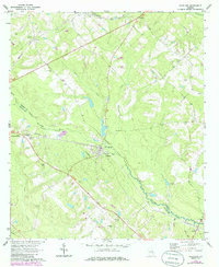
1970 Map of Scotland
USGS Topo · Published 1973About this map
Scotland sits at the heart of this South Georgia landscape, positioned where the Southern railroad intersects the Little Ocmulgee River. The area's mid-century layout is defined by the rural transport network, including the Seaboard Coast Line running through the northern reaches near Erick and Avants. The map reveals a community deeply rooted in its local geography, with numerous family-named landmarks and gathering places such as Stuart Chapel, Bay Springs Ch, and Spring Park. To the southeast, the small settlement of Towns lies near the Little Ocmulgee, highlighting the river's role as a natural boundary between Wheeler and Telfair counties. Cultural markers of the era are visible in the landscape, from the Drive-in Theater west of town to the Radio Tower (WDAX), offering a clear view of the region's social and industrial infrastructure during the early 1970s.
Find a feature on this map
28 named features on this map. Tap any name to fly to it.
Don’t see what you’re looking for? This feature index may not catch every label — zoom into the map to look around manually.
Map Details
Editions of this 1970 Scotland Map
2 editions found
Other maps of this area

1953 · Waycross
USGS Topo · 1:250,000

1957 · Macon
USGS Topo · 1:250,000

1958 · Macon
USGS Topo · 1:250,000

1958 · Waycross
USGS Topo · 1:250,000

1964 · Macon
USGS Topo · 1:250,000

1970 · Glenwood
USGS Topo · 1:24,000

1970 · Alamo
USGS Topo · 1:24,000

1970 · Jordan
USGS Topo · 1:24,000

1971 · Jacksonville NE
USGS Topo · 1:24,000
1971 · Lumber City
USGS Topo · 1:24,000