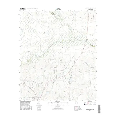
2017 Map of Hazlehurst North
USGS Topo · Published 2017About this map
The Ocmulgee River and Oconee River meet in a significant riverine confluence to form the Altamaha River, a geographic centerpiece of this south Georgia landscape. This network of waterways, including the winding Dead River and several oxbows like Devils Elbow, historically dictated the patterns of settlement and movement across the Wheeler, Montgomery, and Jeff Davis county lines.
Find a feature on this map
104 named features on this map. Tap any name to fly to it.
Don’t see what you’re looking for? This feature index may not catch every label — zoom into the map to look around manually.
Map Details
Editions of this 2017 Hazlehurst North Map
This is the sole edition of this map. No revisions or reprints were ever made.
Other maps of this area

1953 · Waycross
USGS Topo · 1:250,000

1957 · Macon
USGS Topo · 1:250,000

1958 · Macon
USGS Topo · 1:250,000

1958 · Waycross
USGS Topo · 1:250,000

1964 · Macon
USGS Topo · 1:250,000

1970 · Alston
USGS Topo · 1:24,000

1970 · Uvalda
USGS Topo · 1:24,000

1970 · Jordan
USGS Topo · 1:24,000

1970 · Pine Grove
USGS Topo · 1:24,000
1970 · Grays Landing
USGS Topo · 1:24,000