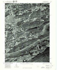
1976 Map of Hazleton
USGS Topo · Published 1979About this map
The city of Hazleton dominates the northwestern portion of this 1976 orthophotograph, showing the dense grid of its urban center alongside the extensive scarring of coal mining activity that surrounds it. The imagery, produced by the Geological Survey and the Soil Conservation Service, provides a stark visual record of the anthracite region's industrial footprint. To the south, the borough of Mc Adoo sits near the base of Spring Mountain, while smaller clusters like Beaver Meadows and the small settlement of Japan appear as island-like developments amidst the disturbed earth and ridges. This aerial perspective captures the complex relationship between residential growth and the heavy extractive industry that defined the landscape of Luzerne County during the mid-1970s, making it possible to trace the exact boundaries of neighborhoods and pits at the time.
Find a feature on this map
6 named features on this map. Tap any name to fly to it.
Don’t see what you’re looking for? This feature index may not catch every label — zoom into the map to look around manually.
Map Details
Editions of this 1976 Hazleton Map
This is the sole edition of this map. No revisions or reprints were ever made.
Other maps of this area

1889 · Hazleton
USGS Topo · 1:62,500

1891 · Wilkesbarre
USGS Topo · 1:62,500

1891 · Hazleton
USGS Topo · 1:62,500

1892 · Mahanoy
USGS Topo · 1:62,500

1893 · Hazleton
USGS Topo · 1:62,500

1893 · Mahanoy
USGS Topo · 1:62,500

1894 · Shickshinny
USGS Topo · 1:62,500

1894 · Wilkesbarre
USGS Topo · 1:62,500

1943 · Scranton
USGS Topo · 1:125,000

1944 · Newark
USGS Topo · 1:250,000