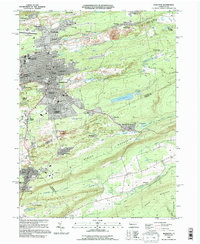
1995 Map of Hazleton
USGS Topo · Published 1996About this map
Hazleton serves as the central hub of this anthracite-rich region, where the urban grid meets a landscape profoundly shaped by industrial excavation. The presence of Strip Mine workings north of Ebervale and near Jeansville illustrates the enduring coal-country character of the terrain. The map captures the dense settlement patterns of the mid-1990s, including residential enclaves like Hazleton Heights and Crystal Ridge, alongside established community anchors such as the Heights Terrace Sch and the Hazleton Municipal Airport.
Find a feature on this map
90 named features on this map. Tap any name to fly to it.
Don’t see what you’re looking for? This feature index may not catch every label — zoom into the map to look around manually.
Map Details
Editions of this 1995 Hazleton Map
This is the sole edition of this map. No revisions or reprints were ever made.
Other maps of this area

1889 · Hazleton
USGS Topo · 1:62,500

1891 · Wilkesbarre
USGS Topo · 1:62,500

1891 · Hazleton
USGS Topo · 1:62,500

1892 · Mahanoy
USGS Topo · 1:62,500

1893 · Hazleton
USGS Topo · 1:62,500

1893 · Mahanoy
USGS Topo · 1:62,500

1894 · Shickshinny
USGS Topo · 1:62,500

1894 · Wilkesbarre
USGS Topo · 1:62,500

1943 · Scranton
USGS Topo · 1:125,000

1944 · Newark
USGS Topo · 1:250,000