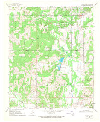
1969 Map of Healdton SE
USGS Topo · Published 1971About this map
Oswalt and Cheek anchor this rural landscape in the late 1960s, situated near the boundary where Carter and Love counties meet. The area is defined by the winding course of Walnut Bayou and Spring Creek, which feed into the prominent Battle Springs Lake. This era shows a community structured around its spiritual and memorial sites, including the Lone Grove Church, Cheek Church, and their associated burial grounds like Oswalt Cemetery and Cheek Cemetery.
Find a feature on this map
23 named features on this map. Tap any name to fly to it.
Don’t see what you’re looking for? This feature index may not catch every label — zoom into the map to look around manually.
Map Details
Editions of this 1969 Healdton SE Map
2 editions found
Other maps of this area

1901 · Ardmore
USGS Topo · 1:125,000

1902 · Gainesville
USGS Topo · 1:125,000

1918 · Ardmore
USGS Topo · 1:125,000

1943 · Gainesville
USGS Topo · 1:125,000

1954 · Sherman
USGS Topo · 1:250,000

1957 · Ardmore
USGS Topo · 1:250,000

1958 · Sherman
USGS Topo · 1:250,000

1963 · Ardmore
USGS Topo · 1:250,000

1964 · Ardmore West
USGS Topo · 1:24,000

1964 · Overbrook
USGS Topo · 1:24,000