
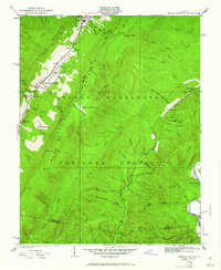
1931 Map of Healing Springs
USGS Topo · Published 1931About this map
The renowned resort landscapes of Bath County take center stage in this early 1930s topographic study. The area around Healing Springs and Hot Springs shows a developed infrastructure of mountain tourism and recreation, featuring the Cascades Golf Club and the nearby Ingalls Landing Field. These established hubs contrast with the more isolated ridge-and-valley settlements found in the eastern reaches of the quadrangle. Small local institutions like Indian Hill Sch and Deeds Sch served the rural families living along the hollows of Beards Mountain and Warm Springs Mountain.
Find a feature on this map
69 named features on this map. Tap any name to fly to it.
Don’t see what you’re looking for? This feature index may not catch every label — zoom into the map to look around manually.
Map Details
Editions of this 1931 Healing Springs Map
2 editions found
Other maps of this area

1894 · Natural Bridge
USGS Topo · 1:125,000

1901 · Monterey
USGS Topo · 1:125,000

1923 · Warm Springs
USGS Topo · 1:48,000

1926 · Warm Springs
USGS Topo · 1:62,500

1929 · Falling Spring
USGS Topo · 1:24,000

1930 · Warm Springs Run
USGS Topo · 1:24,000

1930 · Mountain Grove
USGS Topo · 1:24,000

1932 · Falling Spring
USGS Topo · 1:31,680

1933 · Mountain Grove
USGS Topo · 1:31,680

1933 · Warm Springs Run
USGS Topo · 1:31,680