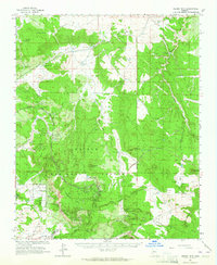
1962 Map of Hearst Mtn.
USGS Topo · Published 1964About this map
The Atchison Topeka And Santa Fe railroad bisects this high-country landscape, following a winding path south of Hearst Mountain and through the KY Hills. This early 1960s survey captures a working ranching and industrial environment within the Kaibab National Forest, defined by a network of water tanks and dams essential for high-altitude livestock operations. Names like Double A Ranch, FY Ranch, and Buss Ranch anchor the southern half of the sheet, while Reeds Winter Camp and Corva Tank suggest the seasonal rhythms of life on the range. The landscape is also marked by resource extraction, with numerous quarries and cinder pits scattered throughout the hills, particularly around Ferno Mesa and Fitzgerald Hill. Topographical landmarks like Antolini Hill and the prominent Paradise Ridge provide natural orientation for those tracing the history of Coconino and Yavapai counties.
Find a feature on this map
87 named features on this map. Tap any name to fly to it.
Don’t see what you’re looking for? This feature index may not catch every label — zoom into the map to look around manually.
Map Details
Editions of this 1962 Hearst Mtn. Map
2 editions found
Other maps of this area

1886 · Chino
USGS Topo · 1:250,000

1891 · Chino
USGS Topo · 1:250,000

1922 · Williams
USGS Topo · 1:125,000

1947 · Ash Fork
USGS Topo · 1:62,500

1947 · Picacho Butte
USGS Topo · 1:62,500

1948 · Ash Fork
USGS Topo · 1:63,360

1948 · Williams
USGS Topo · 1:250,000

1948 · Picacho Butte
USGS Topo · 1:63,360

1949 · Ash Fork
USGS Topo · 1:62,500

1950 · Picacho Butte
USGS Topo · 1:62,500