
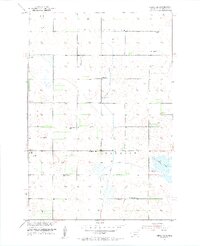
1953 Map of Hecla SE
USGS Topo · Published 1955About this map
Renzienhausen Slough anchors the southeastern landscape of this mid-century survey, illustrating the complex hydrology of northeastern South Dakota. The area is defined by an extensive network of drainage projects, including the Crow Creek Ditch, Detroit Ditch, and Portage Ditch, which were critical for managing the flat prairie terrain for agriculture. Numerous scattered Flowing Wells suggest a reliance on artesian water sources to sustain the local farming economy across the townships of Portage, Lansing, Detroit, and Shelby.
Find a feature on this map
16 named features on this map. Tap any name to fly to it.
Don’t see what you’re looking for? This feature index may not catch every label — zoom into the map to look around manually.
Map Details
Editions of this 1953 Hecla SE Map
2 editions found
Other maps of this area

1894 · Hecla
USGS Topo · 1:62,500

1896 · Columbia
USGS Topo · 1:125,000

1953 · Houghton
USGS Topo · 1:24,000

1953 · Newark SW
USGS Topo · 1:24,000

1953 · Milbank
USGS Topo · 1:250,000

1954 · Daly Corners
USGS Topo · 1:24,000

1954 · Aberdeen
USGS Topo · 1:250,000

1956 · Aberdeen
USGS Topo · 1:250,000
1956 · Hecla
USGS Topo · 1:24,000
1956 · Claremont
USGS Topo · 1:24,000
Featured Places
- Portage Township, SD
- South Detroit Township, SD
- Lansing Township, SD
- Shelby Township, SD
- Hecla Township, SD