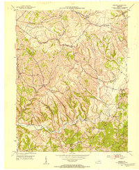
1952 Map of Hedges
USGS Topo · Published 1954About this map
Stoner Creek and Upper Howard Creek carve through this central Kentucky landscape, where small rural hubs and church-centered communities defined local life in the early 1950s. The area is marked by a network of family-named cemeteries such as Rupert Cem and Osborne Cem, alongside local landmarks like Old Indian Field. Strategic transportation is dominated by the Chesapeake and Ohio and Louisville and Nashville railroads, which parallel major ridges and creek beds.
Find a feature on this map
39 named features on this map. Tap any name to fly to it.
Don’t see what you’re looking for? This feature index may not catch every label — zoom into the map to look around manually.
Map Details
Editions of this 1952 Hedges Map
This is the sole edition of this map. No revisions or reprints were ever made.
Other maps of this area

1892 · Richmond
USGS Topo · 1:125,000

1892 · Beattyville
USGS Topo · 1:125,000

1897 · Richmond
USGS Topo · 1:125,000

1950 · Levee
USGS Topo · 1:24,000

1952 · Union City
USGS Topo · 1:24,000

1952 · Palmer
USGS Topo · 1:24,000

1952 · Clay City
USGS Topo · 1:24,000

1952 · Mount Sterling
USGS Topo · 1:24,000

1952 · Austerlitz
USGS Topo · 1:24,000

1952 · Levee
USGS Topo · 1:24,000