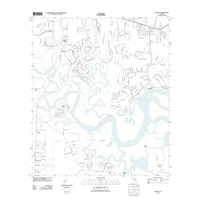
2012 Map of Hedges
USGS Topo · Published 2012About this map
Nassau River dominates this coastal landscape, winding through a complex network of marshy islands and tidal creeks. The water-bound geography includes Halfmoon Island, Pearson Island, and Burton Island, separated by channels like Lofton Cr and Edwards Cr. This 2012 survey illustrates the residential expansion radiating from the Hedges and Yulee Heights area in the north, while smaller coastal settlements like Nassauville and O'Neil sit near the riverbanks. Aviation is a notable presence in the region, with both Nassau Airport and the Flying-A-Ranch Airport situated among the timberlands and subdivisions. Local history is anchored by several burial sites, such as Bowles Cem and Ferreira Cem, alongside navigation landmarks like Lofton Point and the Tisonia Lookout Tower. The drainage patterns of small tributaries like Grandaddy Br and Mill Br suggest the low-lying, swampy nature of the terrain between the developed corridors.
Find a feature on this map
210 named features on this map. Tap any name to fly to it.
Don’t see what you’re looking for? This feature index may not catch every label — zoom into the map to look around manually.
Map Details
Editions of this 2012 Hedges Map
This is the sole edition of this map. No revisions or reprints were ever made.
Other maps of this area

1918 · St Marys
USGS Topo · 1:62,500

1918 · Jacksonville
USGS Topo · 1:62,500

1918 · Mayport
USGS Topo · 1:62,500

1919 · Fernandina
USGS Topo · 1:62,500

1919 · St Marys
USGS Topo · 1:62,500

1944 · Fernandina
USGS Topo · 1:62,500

1948 · Jacksonville
USGS Topo · 1:250,000

1948 · Eastport
USGS Topo · 1:24,000
1950 · Mayport
USGS Topo · 1:24,000

1950 · Trout River
USGS Topo · 1:24,000