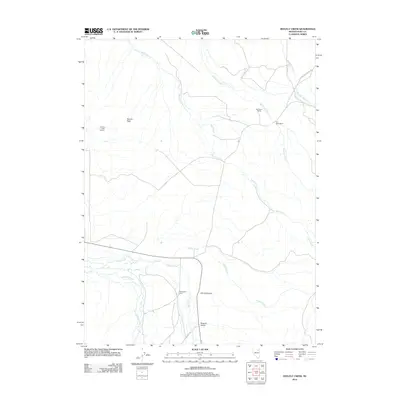
2012 Map of Heelfly Creek
USGS Topo · Published 2012About this map
Deer Horn Ranch and the M J Dahl Ranch occupy a landscape defined by the high-desert drainage systems of eastern Elko County. The map details a complex network of seasonal and perennial waterways, including the winding course of Reed Creek and the eponymous Heelfly Creek, which flow through the broad expanse of Dennis Flats. To the south, the terrain becomes more varied as it transitions into Corral Canyon and the evocatively named Poverty Gulch. The presence of the Seventyone Ranch near the confluence of Secret Creek and Soldier Creek illustrates the importance of water access for these remote agricultural outposts. Infrastructure in this region is focused on the ranching economy, with Co HWY 703 providing primary access alongside the specialized Dennis Flats Pipeline.
Find a feature on this map
16 named features on this map. Tap any name to fly to it.
Don’t see what you’re looking for? This feature index may not catch every label — zoom into the map to look around manually.
Map Details
Editions of this 2012 Heelfly Creek Map
This is the sole edition of this map. No revisions or reprints were ever made.
Other maps of this area

1935 · Halleck
USGS Topo · 1:125,000

1955 · Wells
USGS Topo · 1:250,000

1955 · Elko
USGS Topo · 1:250,000

1958 · Wells
USGS Topo · 1:250,000

1958 · Elko
USGS Topo · 1:250,000

1961 · Wells
USGS Topo · 1:250,000

1962 · Elko
USGS Topo · 1:250,000

1965 · Elko
USGS Topo · 1:250,000

1967 · Herder Creek
USGS Topo · 1:24,000
1967 · Deeth
USGS Topo · 1:24,000