
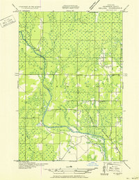
1951 Map of Helena
USGS Topo · Published 1951About this map
The Escanaba River winds through this section of Marquette County, defining a landscape largely shaped by early 20th-century logging and rural development. Compiled from 1930s aerial photography, the map reveals a sparsely settled region anchored by community infrastructure like the Town Hall and multiple local schoolhouses, including Ewing Sch and Ewing Sch No 1. The southern reaches are served by the Lincoln Sch, while the northern wetlands are dotted with seasonal or logging outposts such as Finn Camp and Sherkeys Camp.
Find a feature on this map
13 named features on this map. Tap any name to fly to it.
Don’t see what you’re looking for? This feature index may not catch every label — zoom into the map to look around manually.
Map Details
Editions of this 1951 Helena Map
2 editions found
Other maps of this area

1932 · Rock SW
USGS Topo · 1:31,680

1932 · Helena NW
USGS Topo · 1:31,680

1932 · Helena NE
USGS Topo · 1:31,680

1932 · Whitney NE
USGS Topo · 1:31,680

1932 · Helena SW
USGS Topo · 1:31,680

1932 · Rock NW
USGS Topo · 1:31,680

1932 · Helena
USGS Topo · 1:31,680

1932 · Gladstone NW
USGS Topo · 1:31,680

1950 · Gladstone NW
USGS Topo · 1:31,680

1951 · Helena SW
USGS Topo · 1:31,680