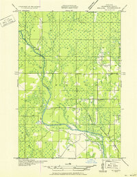
1951 Map of Helena SE
USGS Topo · Published 1951About this map
The Escanaba River winds through this section of the Upper Peninsula, defining a landscape dominated by timber and early rural infrastructure. This 1951 advance sheet reflects fieldwork dating back to the 1930s, capturing a period when small camp settlements like Finn Camp and Sharkey Camp remained significant landmarks in the backcountry. The eastern portion of the quadrangle shows a more organized pattern of development, following the corridor of the Chicago and Northwestern railroad. Education and civic life in the township are evidenced by the presence of the Town Hall and several rural schoolhouses, including the Lincoln Sch and Ewing Sch No 1. These sites, along with the numerous wetland indicators and small tributaries like Hunters Brook, illustrate the persistent challenge of settling the cedar swamps and hardwood forests of Marquette County.
Find a feature on this map
13 named features on this map. Tap any name to fly to it.
Don’t see what you’re looking for? This feature index may not catch every label — zoom into the map to look around manually.
Map Details
Editions of this 1951 Helena SE Map
2 editions found

Other maps of this area

1932 · Rock SW
USGS Topo · 1:31,680

1932 · Helena NW
USGS Topo · 1:31,680

1932 · Helena NE
USGS Topo · 1:31,680

1932 · Whitney NE
USGS Topo · 1:31,680

1932 · Helena SW
USGS Topo · 1:31,680

1932 · Rock NW
USGS Topo · 1:31,680

1932 · Helena
USGS Topo · 1:31,680

1932 · Gladstone NW
USGS Topo · 1:31,680

1950 · Gladstone NW
USGS Topo · 1:31,680

1951 · Helena SW
USGS Topo · 1:31,680