
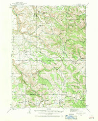
1924 Map of Hell Creek
USGS Topo · Published 1958About this map
The small settlement of Dehlin and its namesake Dehlin School anchor this 1924 survey of the Idaho high country. Located on the border of Bonneville and Bingham Counties, the landscape is defined by the sharp transition from ranching and farming valleys to the timbered slopes of the Caribou National Forest. The Boise Base Line runs through the heart of the map, serving as a critical survey marker for the region's development. This era shows a network of rural education, with the Pipe Creek School serving families near the headwaters of Bear Creek. The rugged geography includes notable landmarks such as Castle Rock and the extensive Fall Creek Basin, which provided a natural hub for early resource management at the Hell Creek Ranger Sta. High points like Mt Baldy and Skelly Hill overlook a complex drainage system of creeks including Indian Fork and Bulls Creek, which were vital for irrigation and livestock in the early twentieth century.
Find a feature on this map
47 named features on this map. Tap any name to fly to it.
Don’t see what you’re looking for? This feature index may not catch every label — zoom into the map to look around manually.
Map Details
Editions of this 1924 Hell Creek Map
2 editions found
Other maps of this area

1917 · Cranes Flat
USGS Topo · 1:62,500

1918 · Paradise Valley
USGS Topo · 1:62,500

1924 · Ammon
USGS Topo · 1:62,500

1926 · Hell Creek
USGS Topo · 1:62,500

1932 · Irwin
USGS Topo · 1:96,000

1935 · Irwin
USGS Topo · 1:125,000

1943 · Garns Mtn
USGS Topo · 1:62,500

1946 · Garns Mtn
USGS Topo · 1:62,500

1950 · Rigby
USGS Topo · 1:62,500

1950 · Rigby SE
USGS Topo · 1:24,000