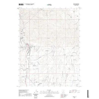
2020 Map of Helper
USGS Topo · Published 2020About this map
Helper serves as the focal point for this industrial corridor in Carbon County, where the Price River carves through the formidable Book Cliffs. The geography is defined by a dense concentration of cemeteries, including Castle Gate Cem, Mountain View Cem, and the Central Cem / Slovenian Cem, reflecting the area's deep coal mining and immigrant heritage. Small settlements like Kenilworth, Spring Glen, and Carbonville are threaded together by a complex network of transportation and irrigation, including the Spring Glen Canal Rd and the Price Canal. The map reveals the intricate intersection of rail history and modern infrastructure, with labels such as Old Kenilworth RR and the Kenilworth RR Grade tracing former industrial pathways. From the depths of Price Canyon to the heights of the Book Cliffs, the landscape remains a testament to the heavy industry and community life centered around the river and rails.
Find a feature on this map
107 named features on this map. Tap any name to fly to it.
Don’t see what you’re looking for? This feature index may not catch every label — zoom into the map to look around manually.
Map Details
Editions of this 2020 Helper Map
This is the sole edition of this map. No revisions or reprints were ever made.
Other maps of this area

1886 · Price River
USGS Topo · 1:250,000

1896 · Price River
USGS Topo · 1:250,000

1914 · Castle Gate
USGS Topo · 1:62,500

1915 · Wellington
USGS Topo · 1:62,500

1916 · Castle Gate
USGS Topo · 1:62,500

1956 · Price
USGS Topo · 1:250,000

1960 · Price
USGS Topo · 1:250,000

1962 · Price
USGS Topo · 1:250,000
1969 · Kyune
USGS Topo · 1:24,000
1969 · Minnie Maud Creek West
USGS Topo · 1:24,000