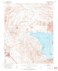
1952 Map of Henderson
USGS Topo · Published 1956About this map
Industrial expansion in the Mojave Desert defines the landscape south of Lake Mead in the early 1950s. The settlement of Henderson is anchored by the massive Manganese Plant and sprawling Tailings Ponds, reflecting the town's wartime origins and postwar industrial role. Workforce housing is clustered nearby at Carver Park and Victory Village, connected by the Union Pacific rail lines that provided the essential link to global markets.
Find a feature on this map
37 named features on this map. Tap any name to fly to it.
Don’t see what you’re looking for? This feature index may not catch every label — zoom into the map to look around manually.
Map Details
Editions of this 1952 Henderson Map
2 editions found

Other maps of this area

1886 · Camp Mohave
USGS Topo · 1:250,000

1886 · Saint Thomas
USGS Topo · 1:250,000

1892 · Camp Mohave
USGS Topo · 1:250,000

1893 · Saint Thomas
USGS Topo · 1:250,000

1907 · Las Vegas
USGS Topo · 1:250,000

1908 · Las Vegas
USGS Topo · 1:250,000

1910 · Ivanpah
USGS Topo · 1:250,000

1912 · Ivanpah
USGS Topo · 1:250,000

1926 · Nelson
USGS Topo · 1:96,000

1926 · Boulder Canyon
USGS Topo · 1:96,000