
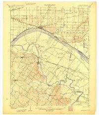
1914 Map of Henderson
USGS Topo · Published 1914About this map
The Ohio River dominates this 1914 survey, snaking between the growing industrial centers of Evansville, Indiana, and Henderson, Kentucky. This era captures the river before modern channelization, marked by intricate backwaters like Deep Slough, Horse Pond, and Bee Slough. Infrastructure is heavy along the banks, featuring Lock and Dam No 48 and a Car Ferry connecting the two states.
Find a feature on this map
91 named features on this map. Tap any name to fly to it.
Don’t see what you’re looking for? This feature index may not catch every label — zoom into the map to look around manually.
Map Details
Editions of this 1914 Henderson Map
This is the sole edition of this map. No revisions or reprints were ever made.
Other maps of this area

1901 · Haubstadt
USGS Topo · 1:62,500

1902 · Ditney
USGS Topo · 1:125,000

1902 · Boonville
USGS Topo · 1:62,500

1903 · Haubstadt
USGS Topo · 1:62,500

1903 · New Harmony
USGS Topo · 1:62,500

1903 · Patoka
USGS Topo · 1:125,000
1905 · Newburg
USGS Topo · 1:62,500
1906 · Sebree
USGS Topo · 1:62,500

1907 · Morganfield
USGS Topo · 1:62,500

1908 · Calhoun
USGS Topo · 1:62,500