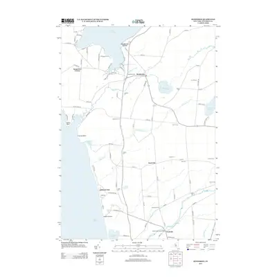
2013 Map of Henderson
USGS Topo · Published 2013About this map
The Lake Ontario shoreline near Henderson Harbor and Southwich Beach defines this section of Jefferson County. Agricultural heritage is prominent across the landscape, with family-named tracts and farmsteads like Bonnyland Far, Dodge Farms, and Sheland Farms situated between the waterways of Stony Creek and Little Stony Creek. The village of Henderson serves as a central hub, surrounded by smaller historic crossroads such as Aspinwall Corners, Scotts Corners, and Hammond Corners. Genealogists will find a high density of small burial grounds preserved throughout the rural township, including Stowles Cemetery, Mixer Cemetery, and Galilea Cemetery. The presence of the Graham Creek Canal and various coastal features like Sawyer Point and El Dorado Beach illustrate the area's dual character as both a productive farming region and a gateway to the Great Lakes.
Find a feature on this map
89 named features on this map. Tap any name to fly to it.
Don’t see what you’re looking for? This feature index may not catch every label — zoom into the map to look around manually.
Map Details
Editions of this 2013 Henderson Map
This is the sole edition of this map. No revisions or reprints were ever made.
Other maps of this area

1893 · Sackets Harbor
USGS Topo · 1:62,500

1895 · Sacketts Harbor
USGS Topo · 1:62,500

1895 · Stony Island
USGS Topo · 1:62,500

1895 · Pulaski
USGS Topo · 1:62,500

1942 · Stony Point
USGS Topo · 1:31,680

1942 · Henderson Bay
USGS Topo · 1:31,680

1942 · Point Peninsula
USGS Topo · 1:31,680

1942 · Sandy Creek
USGS Topo · 1:24,000

1943 · Henderson
USGS Topo · 1:31,680
1943 · Sackets Harbor
USGS Topo · 1:31,680