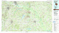
1986 Map of Henderson
USGS Topo · Published 1991About this map
Henderson and Carthage anchor the southern half of this mid-1980s survey, where the piney woods of East Texas meet the Louisiana border. The landscape is defined by massive surface industrial operations and extensive water management, most notably the large Strip Mine works and the cooling waters of Martin Lake. These features sit alongside established rural communities like Tatum, Beckville, and Minden, many of which maintain deep ties to the land through local landmarks such as Harris Chapel Cem and Antioch Cem.
Find a feature on this map
119 named features on this map. Tap any name to fly to it.
Don’t see what you’re looking for? This feature index may not catch every label — zoom into the map to look around manually.
Map Details
Editions of this 1986 Henderson Map
2 editions found
Other maps of this area

1935 · Henderson
USGS Topo · 1:48,000

1936 · Kilgore
USGS Topo · 1:48,000

1937 · Troupe
USGS Topo · 1:48,000

1938 · Winona
USGS Topo · 1:48,000

1939 · Henderson
USGS Topo · 1:62,500

1940 · Kilgore
USGS Topo · 1:62,500

1943 · Troup
USGS Topo · 1:62,500

1943 · Winona
USGS Topo · 1:62,500

1943 · Waskom
USGS Topo · 1:62,500

1943 · Cushing
USGS Topo · 1:62,500