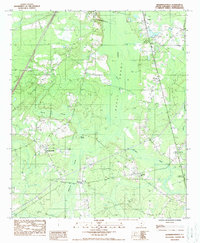
1988 Map of Hendersonville
USGS Topo · Published 1988About this map
The Ashepoo River meanders through the heart of the Great Swamp in this late-twentieth-century study of Colleton County. The landscape is defined by its extensive wetlands, including Remick Swamp and Bluehouse Swamp, which separate several small communities. The settlement of Hendersonville serves as a primary reference point in the western section, while Catholic Hill and Bluehouse Corners are situated to the southeast. The northeastern boundary touches the Walterboro Corp Bdy, indicating the edge of the regional hub. Local industry and transit are represented by the presence of railroads passing through Ritter and Drawdy, while smaller features like Pringle Creek and various cemeteries provide critical data for those tracing local family history and the historical geography of the Lowcountry.
Find a feature on this map
14 named features on this map. Tap any name to fly to it.
Don’t see what you’re looking for? This feature index may not catch every label — zoom into the map to look around manually.
Map Details
Editions of this 1988 Hendersonville Map
This is the sole edition of this map. No revisions or reprints were ever made.
Other maps of this area

1918 · Walterboro
USGS Topo · 1:62,500

1918 · Green Pond
USGS Topo · 1:62,500

1918 · Yemassee
USGS Topo · 1:62,500

1919 · Cummings
USGS Topo · 1:62,500

1943 · Yemassee
USGS Topo · 1:62,500

1943 · Green Pond
USGS Topo · 1:62,500

1943 · Cummings
USGS Topo · 1:62,500

1943 · Walterboro
USGS Topo · 1:62,500

1947 · Savannah
USGS Topo · 1:250,000

1948 · Savannah
USGS Topo · 1:250,000