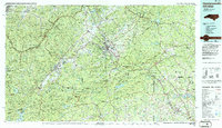
1986 Map of Hendersonville
USGS Topo · Published 1986About this map
The Blue Ridge Mountains dominate this 1980s landscape, illustrating the transition from the high-elevation wilderness of the Pisgah National Forest and Nantahala National Forest to the growing communities along the Southern railroad line. At the center, Hendersonville serves as a hub for smaller mountain settlements like Balfour and Flat Rock, while to the west, the Davidson River and French Broad River converge near Brevard.
Find a feature on this map
93 named features on this map. Tap any name to fly to it.
Don’t see what you’re looking for? This feature index may not catch every label — zoom into the map to look around manually.
Map Details
Editions of this 1986 Hendersonville Map
2 editions found
Other maps of this area

1886 · Walhalla
USGS Topo · 1:125,000

1888 · Pickens
USGS Topo · 1:125,000

1891 · Cowee
USGS Topo · 1:125,000

1892 · Walhalla
USGS Topo · 1:125,000

1893 · Mt Guyot
USGS Topo · 1:125,000

1894 · Asheville
USGS Topo · 1:125,000

1894 · Pickens
USGS Topo · 1:125,000

1896 · Walhalla
USGS Topo · 1:125,000

1897 · Cowee
USGS Topo · 1:125,000

1900 · Mount Mitchell
USGS Topo · 1:125,000