
1943 Map of Henry
USGS Topo · Published 1962About this map
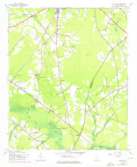
Black River Swamp and Campbell Swamp dominate the low-lying terrain of this Williamsburg County landscape, where rural life in the 1940s followed the edges of these water systems. The Seaboard Air Line railroad cuts through the northern section, connecting the small settlements of Henry and Hemingway to the wider region. Local community centers are clearly identified through a network of country churches and schools, such as Sand Hill Ch and Bethel Sch, which served the families living in clusters like Poplar Hill and Gordonville. The map captures a transition point at the Williamsburg and Georgetown county line, showing how the early road network converged at sites like Brunson Crossroads and Union Crossroads. A Lookout Tower positioned near Mingo Creek reflects the vital role of forest monitoring in this timber-rich region of the coastal plain.
Find a feature on this map
43 named features on this map. Tap any name to fly to it.
Don’t see what you’re looking for? This feature index may not catch every label — zoom into the map to look around manually.
Map Details
Editions of this 1943 Henry Map
2 editions found
Other maps of this area

1943 · Carvers Bay
USGS Topo · 1:24,000

1943 · Rhems
USGS Topo · 1:24,000

1943 · Outland
USGS Topo · 1:24,000

1944 · Outland
USGS Topo · 1:31,680

1946 · Hyman
USGS Topo · 1:62,500

1946 · Johnsonville
USGS Topo · 1:62,500

1946 · Indiantown
USGS Topo · 1:62,500

1949 · Georgetown
USGS Topo · 1:250,000

1967 · Georgetown
USGS Topo · 1:250,000

1974 · Georgetown
USGS Topo · 1:250,000