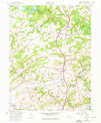
1958 Map of Hereford
USGS Topo · Published 1975About this map
Prettyboy Reservoir and the winding course of Gunpowder Falls anchor this mid-century survey of northern Baltimore County. The landscape reflects a transition from rural agricultural land to a more connected suburban corridor, notably marked by the introduction of purple-revision highway interchanges and residential expansion near Hereford. While modern transit begins to overlay the terrain, the map preserves the older structural footprint of the region, including numerous small settlements like Yeoho, Belfast, and Sparks. For local historians and genealogists, the map is a primary resource for locating country churches and family-named landmarks, ranging from Mt Carmel Ch in the west to Immanuel Ch near Glencoe. The inclusion of the Penn Central rail line, with stops at Sparks Sta and Glencoe Sta, illustrates the persistent importance of the railroad for these outlying Maryland communities.
Find a feature on this map
86 named features on this map. Tap any name to fly to it.
Don’t see what you’re looking for? This feature index may not catch every label — zoom into the map to look around manually.
Map Details
Editions of this 1958 Hereford Map
Other maps of this area

1892 · Ellicott
USGS Topo · 1:62,500

1894 · Ellicott
USGS Topo · 1:62,500

1894 · Baltimore
USGS Topo · 1:62,500

1899 · Baltimore
USGS Topo · 1:62,500

1900 · Parkton
USGS Topo · 1:62,500

1902 · Parkton
USGS Topo · 1:62,500

1904 · Baltimore
USGS Topo · 1:62,500

1905 · Westminster
USGS Topo · 1:62,500

1906 · Ellicott
USGS Topo · 1:62,500

1908 · Patapsco
USGS Topo · 1:125,000