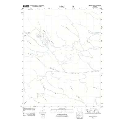
2011 Map of Herlick Canyon
USGS Topo · Published 2011About this map
West Spanish Peak overlooks a high-elevation landscape in Las Animas County where the Apishapa River and North Fork Apishapa River originate. The drainage system is remarkably intricate, with deep cuts like Herlick Canyon, Tarrino Canyon, and Jarosa Canyon defining the local geography. Human presence is marked by isolated infrastructure and small family landmarks rather than dense settlements, centered around the Spanish Peaks Ranch Number 13 Dam. Small burial grounds, including the Scott Cemetery, Prince Cemetery, and Hicks Cemetery, are tucked away in the canyon floors, offering specific points of interest for genealogical research. The area is also home to geological and recreational landmarks like the Apishapa Arch and the Apishapa Picnic Area, linked by a network of county roads such as County Rd 42 and Aspen Rose Dr.
Find a feature on this map
38 named features on this map. Tap any name to fly to it.
Don’t see what you’re looking for? This feature index may not catch every label — zoom into the map to look around manually.
Map Details
Editions of this 2011 Herlick Canyon Map
This is the sole edition of this map. No revisions or reprints were ever made.
Other maps of this area

1891 · Spanish Peaks
USGS Topo · 1:125,000

1893 · Spanish Peaks
USGS Topo · 1:125,000

1895 · Spanish Peaks
USGS Topo · 1:125,000

1897 · Spanish Peaks
USGS Topo · 1:125,000

1900 · Spanish Peaks
USGS Topo · 1:125,000

1954 · Trinidad
USGS Topo · 1:250,000

1955 · Trinidad
USGS Topo · 1:250,000

1958 · Trinidad
USGS Topo · 1:250,000

1959 · Trinidad
USGS Topo · 1:250,000
1963 · Cuchara
USGS Topo · 1:24,000