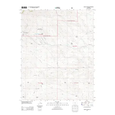
2013 Map of Herlick Canyon
USGS Topo · Published 2013About this map
San Isabel National Forest blankets the northern portion of this landscape, where the headwaters of the Apishapa River and S Fork Trujillo Cr carve through high-elevation terrain. This 2013 survey documents a remote section of Las Animas County characterized by deep drainage systems like Jarosa Canyon and Herlick Canyon. The land management pattern reflects a mix of protected forest and private holdings, notably the Spanish Peaks Ranch Reservoir Number 1. For those researching local burial sites and family history, the map precisely locates three small cemeteries: Prince Cem, Scott Cem, and Hicks Cem. These landmarks, along with name-bearing routes such as Aspen Rose Rd and W Spanish Peak Dr, provide essential spatial context for the early 21st-century geographic layout of this mountain region.
Find a feature on this map
46 named features on this map. Tap any name to fly to it.
Don’t see what you’re looking for? This feature index may not catch every label — zoom into the map to look around manually.
Map Details
Editions of this 2013 Herlick Canyon Map
This is the sole edition of this map. No revisions or reprints were ever made.
Other maps of this area

1891 · Spanish Peaks
USGS Topo · 1:125,000

1893 · Spanish Peaks
USGS Topo · 1:125,000

1895 · Spanish Peaks
USGS Topo · 1:125,000

1897 · Spanish Peaks
USGS Topo · 1:125,000

1900 · Spanish Peaks
USGS Topo · 1:125,000

1954 · Trinidad
USGS Topo · 1:250,000

1955 · Trinidad
USGS Topo · 1:250,000

1958 · Trinidad
USGS Topo · 1:250,000

1959 · Trinidad
USGS Topo · 1:250,000
1963 · Cuchara
USGS Topo · 1:24,000