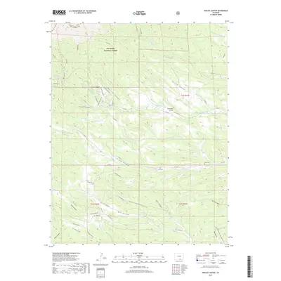
2019 Map of Herlick Canyon
USGS Topo · Published 2019About this map
San Isabel National Forest dominates this high-altitude landscape of southern Colorado, characterized by a complex network of deep drainages including Herlick Canyon and Jarosa Canyon. The topography is marked by several geologic and natural landmarks, such as the Apishapa Arch and the Twin Peaks Window, which overlook the headwaters of the Apishapa River. Scattered throughout these canyons are signs of rural life and land use, from the Cimmaron Ranch to the uniquely named Shortys Hideout. For genealogists, the map is a vital record of local family history, preserving the locations of remote burial grounds like Scott Cem, Prince Cem, and Hicks Cem. The southern portion of the map includes the Spanish Peaks SWA - Sakariason Tract, illustrating the continued importance of state-managed lands in this rugged portion of Las Animas County.
Find a feature on this map
53 named features on this map. Tap any name to fly to it.
Don’t see what you’re looking for? This feature index may not catch every label — zoom into the map to look around manually.
Map Details
Editions of this 2019 Herlick Canyon Map
This is the sole edition of this map. No revisions or reprints were ever made.
Other maps of this area

1891 · Spanish Peaks
USGS Topo · 1:125,000

1893 · Spanish Peaks
USGS Topo · 1:125,000

1895 · Spanish Peaks
USGS Topo · 1:125,000

1897 · Spanish Peaks
USGS Topo · 1:125,000

1900 · Spanish Peaks
USGS Topo · 1:125,000

1954 · Trinidad
USGS Topo · 1:250,000

1955 · Trinidad
USGS Topo · 1:250,000

1958 · Trinidad
USGS Topo · 1:250,000

1959 · Trinidad
USGS Topo · 1:250,000
1963 · Cuchara
USGS Topo · 1:24,000