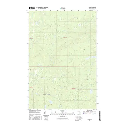
2017 Map of Herman
USGS Topo · Published 2017About this map
Herman stands as the primary settlement in this wooded portion of Baraga County, situated near the Herman Cem. The landscape is defined by the complex drainage system of the Silver River and its various branches, including the E Br Silver River and Upper Silver River Falls. This 2017 survey details the rural road network that connects the scattered homesteads and timberlands, with routes like Herman Nestoria Rd, Celotex Rd, and Summit Rd providing access through the hilly interior. Numerous small, isolated bodies of water are tucked into the terrain, such as Little Summit Lake, Kortio Lake, and Dirkman Lake. The abundance of named falls, including Harley Falls and Upper Silver Falls, suggests a rugged topography where water frequently drops over the Canadian Shield's southern edge.
Find a feature on this map
37 named features on this map. Tap any name to fly to it.
Don’t see what you’re looking for? This feature index may not catch every label — zoom into the map to look around manually.
Map Details
Editions of this 2017 Herman Map
This is the sole edition of this map. No revisions or reprints were ever made.
Other maps of this area

1954 · Skanee
USGS Topo · 1:62,500

1954 · Keweenaw Bay
USGS Topo · 1:62,500

1955 · Herman
USGS Topo · 1:62,500

1956 · Three Lakes
USGS Topo · 1:24,000

1956 · Michigamme
USGS Topo · 1:62,500

1958 · Iron River
USGS Topo · 1:250,000

1960 · Iron River
USGS Topo · 1:250,000

1961 · Iron River
USGS Topo · 1:250,000

1967 · Iron River
USGS Topo · 1:250,000
1984 · Aura
USGS Topo · 1:24,000