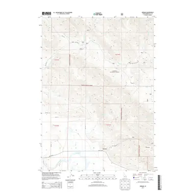
2013 Map of Herman
USGS Topo · Published 2013About this map
The settlement of Herman sits at a remote crossroads in eastern Idaho, where the northern marshes of Grays Lake meet the high ridges of the Caribou National Forest. This 2013 landscape is defined by the hydrologic transition from the sprawling wetlands of the lake to the numerous drainages that carve through the surrounding timberland, including Shirley Cr, Clerk Cr, and Brockman Cr. The road network here, featuring Grays Lake Rd and Brockman Rd, highlights the area's history as a hub for ranching and forest access. Further east, the high-altitude topography opens into the Della Basin, while the Grays Lake Outlet drains the basin to the southwest. The map documents a sparsely populated but geographically complex region where federal forest lands and local grazing traditions intersect.
Find a feature on this map
27 named features on this map. Tap any name to fly to it.
Don’t see what you’re looking for? This feature index may not catch every label — zoom into the map to look around manually.
Map Details
Editions of this 2013 Herman Map
This is the sole edition of this map. No revisions or reprints were ever made.
Other maps of this area

1917 · Cranes Flat
USGS Topo · 1:62,500

1924 · Hell Creek
USGS Topo · 1:62,500

1926 · Hell Creek
USGS Topo · 1:62,500

1932 · Irwin
USGS Topo · 1:96,000

1935 · Irwin
USGS Topo · 1:125,000

1955 · Driggs
USGS Topo · 1:250,000

1958 · Driggs
USGS Topo · 1:250,000

1962 · Driggs
USGS Topo · 1:250,000
1966 · Bear Island
USGS Topo · 1:24,000

1966 · Big Elk Mtn
USGS Topo · 1:24,000