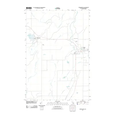
2011 Map of Hermansville
USGS Topo · Published 2011About this map
Hermansville, Spalding, and Powers anchor this 2011 survey of Spalding Township in Menominee County, highlighting the established transport and civic nodes of the Upper Peninsula. The landscape is defined by an intricate network of waterways, including the Little Cedar River and Beaver Dam Creek, which wind through the township's agricultural and wooded terrain. Significant local heritage markers include the Meyer Cemetery and Spalding Cemetery, providing essential coordinates for genealogists and regional historians. The presence of the Spalding Lookout Tower reflects the area's ongoing relationship with forest management, while several post offices—Hermansville, Spalding, and Powers—delineate the centers of community life. Further south, the map details the hydrology around Kloman Lake and Fisher Lake, showing the transition from small settlements to the broader natural wetlands and drainages typical of this Michigan region.
Find a feature on this map
22 named features on this map. Tap any name to fly to it.
Don’t see what you’re looking for? This feature index may not catch every label — zoom into the map to look around manually.
Map Details
Editions of this 2011 Hermansville Map
This is the sole edition of this map. No revisions or reprints were ever made.
Other maps of this area

1954 · Escanaba
USGS Topo · 1:250,000

1956 · Foster City
USGS Topo · 1:62,500

1957 · Escanaba
USGS Topo · 1:250,000

1958 · Escanaba
USGS Topo · 1:250,000

1963 · Bark River
USGS Topo · 1:62,500

1963 · Powers
USGS Topo · 1:62,500

1963 · Schaffer
USGS Topo · 1:62,500

1982 · Escanaba
USGS Topo · 1:100,000
1986 · Waucedah
USGS Topo · 1:24,000
1986 · Vega
USGS Topo · 1:24,000