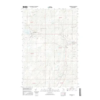
2017 Map of Hermansville
USGS Topo · Published 2017About this map
Hermansville serves as a focal point in this Upper Peninsula landscape, situated where the Escanaba to Hermansville State Trail meets a network of local roads like Main St and Railroad Ave. The settlement pattern follows the legacy of early industrial and transit corridors, connecting to nearby Spalding and Powers. To the west, Hermansville Lake and the Little Cedar River define the local hydrology, while the surrounding townships are dotted with smaller water bodies such as Wheeler Lake and Kloman Lake. Local history and genealogy are anchored by specific landmarks including Meyer Cem and Spalding Cem. The terrain is characterized by numerous small tributaries like Holmes Cr and Alder Brook that feed into the larger Cedar River system, illustrating the well-watered character of Menominee County.
Find a feature on this map
86 named features on this map. Tap any name to fly to it.
Don’t see what you’re looking for? This feature index may not catch every label — zoom into the map to look around manually.
Map Details
Editions of this 2017 Hermansville Map
This is the sole edition of this map. No revisions or reprints were ever made.
Other maps of this area

1954 · Escanaba
USGS Topo · 1:250,000

1956 · Foster City
USGS Topo · 1:62,500

1957 · Escanaba
USGS Topo · 1:250,000

1958 · Escanaba
USGS Topo · 1:250,000

1963 · Bark River
USGS Topo · 1:62,500

1963 · Powers
USGS Topo · 1:62,500

1963 · Schaffer
USGS Topo · 1:62,500

1982 · Escanaba
USGS Topo · 1:100,000
1986 · Waucedah
USGS Topo · 1:24,000
1986 · Vega
USGS Topo · 1:24,000