1980 Map of Hermitage
USGS Topo · Published 1982About this map
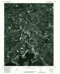
Hermitage serves as the focal point of this orthophotomap, which utilizes 1980 aerial imagery to document the landscape of Hickory County during a period of transition. The imagery clearly delineates the winding path of the Pomme De Terre River as it feeds into the northern reaches of the Pomme De Terre Lake, a massive reservoir that reshaped the local topography. This 1982 edition by the Geological Survey and the Missouri Department of Natural Resources provides a detailed visual record of land use, from the dense forest cover on the hillsides to the cleared agricultural plots and small settlements like Galmey and Nemo. The juxtaposition of the natural river bends against the expansive man-made lake reveals the impact of water management projects on the rural Ozark landscape, offering genealogists and historians a precise view of property boundaries and infrastructure just as the region was becoming a recreational destination.
Find a feature on this map
5 named features on this map. Tap any name to fly to it.
Don’t see what you’re looking for? This feature index may not catch every label — zoom into the map to look around manually.
Map Details
Editions of this 1980 Hermitage Map
This is the sole edition of this map. No revisions or reprints were ever made.
Other maps of this area

1884 · Bolivar
USGS Topo · 1:125,000

1887 · Warsaw
USGS Topo · 1:125,000

1892 · Bolivar
USGS Topo · 1:125,000

1894 · Warsaw
USGS Topo · 1:125,000

1942 · Elkton
USGS Topo · 1:24,000

1945 · Fristoe
USGS Topo · 1:62,500

1947 · Jefferson City
USGS Topo · 1:250,000

1949 · Elkton
USGS Topo · 1:24,000

1949 · Sentinel
USGS Topo · 1:24,000

1950 · Elkton
USGS Topo · 1:24,000