1982 Map of Hermitage
USGS Topo · Published 1982About this map
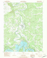
The town of Hermitage serves as the focal point of this 1980s-era survey, positioned within the winding bends of the Pomme De Terre River. The landscape is defined by the transition from riverine topography to the impounded waters of the Harry S Truman Reservoir and Pomme De Terre Lake. Cultural and genealogical sites are well-represented, including Dorman Cem, Liberty Cem, and the St Bernadette Ch, reflecting the deep-rooted community structure of Hickory County during this period.
Find a feature on this map
35 named features on this map. Tap any name to fly to it.
Don’t see what you’re looking for? This feature index may not catch every label — zoom into the map to look around manually.
Map Details
Editions of this 1982 Hermitage Map
This is the sole edition of this map. No revisions or reprints were ever made.
Other maps of this area

1884 · Bolivar
USGS Topo · 1:125,000

1887 · Warsaw
USGS Topo · 1:125,000

1892 · Bolivar
USGS Topo · 1:125,000

1894 · Warsaw
USGS Topo · 1:125,000

1942 · Elkton
USGS Topo · 1:24,000

1945 · Fristoe
USGS Topo · 1:62,500

1947 · Jefferson City
USGS Topo · 1:250,000

1949 · Elkton
USGS Topo · 1:24,000

1949 · Sentinel
USGS Topo · 1:24,000

1950 · Elkton
USGS Topo · 1:24,000