
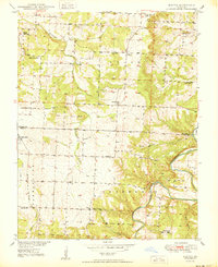
1950 Map of Elkton
USGS Topo · Published 1950About this map
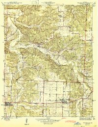
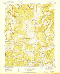
Elkton and the surrounding township of Tyler serve as the focal points for this mid-century topographic record, where the rural landscape is defined by a dense network of country schools and family-named cemeteries. The topography is shaped by the winding Pomme De Terre River and Weaubleau Creek, which cut through the Ozark plateau. To the west, the St Louis - San Francisco railroad corridor passes through Flemington, connecting the local agricultural economy to broader regional markets.
Find a feature on this map
31 named features on this map. Tap any name to fly to it.
Don’t see what you’re looking for? This feature index may not catch every label — zoom into the map to look around manually.
Map Details
Editions of this 1950 Elkton Map
2 editions found
Other maps of this area

1884 · Bolivar
USGS Topo · 1:125,000

1886 · Stockton
USGS Topo · 1:125,000

1892 · Bolivar
USGS Topo · 1:125,000

1940 · Weaubleau
USGS Topo · 1:24,000

1942 · Elkton
USGS Topo · 1:24,000

1944 · Humansville
USGS Topo · 1:24,000
1944 · Weaubleau
USGS Topo · 1:24,000

1949 · Elkton
USGS Topo · 1:24,000

1949 · Sentinel
USGS Topo · 1:24,000
1950 · Sentinel
USGS Topo · 1:24,000