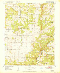
1950 Map of Elkton
USGS Topo · Published 1950About this map
Flemington and Elkton anchor this mid-century look at the rural borderlands of Hickory and Polk Counties, a landscape defined by the winding course of the Pomme de Terre River and Weaubleau Creek. This 1950 edition captures the region's dense network of neighborhood centers before the consolidation of many local institutions, shown through a high concentration of country schoolhouses like Prairie Valley Sch, Sunny Slope Sch, and Union Sch. For genealogists, the map is particularly valuable for its precise location of family-named cemeteries and rural places of worship, including Mission Chapel and Durnell Chapel. The terrain transitions from the upland flats near Rondo to the dissected valleys of Horn Hollow and Cave Spring Hollow, reflecting the traditional Missouri Ozarks pattern of settlement where small farmsteads and schools dotted the ridges above the river bends.
Find a feature on this map
34 named features on this map. Tap any name to fly to it.
Don’t see what you’re looking for? This feature index may not catch every label — zoom into the map to look around manually.
Map Details
Editions of this 1950 Elkton Map
2 editions found
Other maps of this area

1884 · Bolivar
USGS Topo · 1:125,000

1886 · Stockton
USGS Topo · 1:125,000

1892 · Bolivar
USGS Topo · 1:125,000

1940 · Weaubleau
USGS Topo · 1:24,000

1942 · Elkton
USGS Topo · 1:24,000

1944 · Humansville
USGS Topo · 1:24,000
1944 · Weaubleau
USGS Topo · 1:24,000

1949 · Elkton
USGS Topo · 1:24,000

1949 · Sentinel
USGS Topo · 1:24,000

1950 · Elkton
USGS Topo · 1:24,000