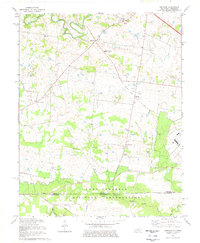
1978 Map of Herndon
USGS Topo · Published 1978About this map
The Fort Campbell Military Reservation dominates the southern landscape of this Christian County survey, stretching across the State Line into Tennessee. The area is defined by a dense network of country roads connecting small agricultural communities like Herndon and Bennettstown. Notable local landmarks include the South Christian Sch and several historical houses of worship such as McKenzie Ch and New Asia Ch, reflecting the deep-rooted social fabric of the rural Pennyroyal Plain.
Find a feature on this map
36 named features on this map. Tap any name to fly to it.
Don’t see what you’re looking for? This feature index may not catch every label — zoom into the map to look around manually.
Map Details
Editions of this 1978 Herndon Map
2 editions found
Other maps of this area

1944 · Clarksville
USGS Topo · 1:50,000

1950 · Caledonia
USGS Topo · 1:24,000

1951 · Church Hill
USGS Topo · 1:24,000

1951 · Caledonia
USGS Topo · 1:24,000

1951 · Hopkinsville
USGS Topo · 1:24,000

1951 · Roaring Spring
USGS Topo · 1:24,000

1951 · New Providence
USGS Topo · 1:24,000

1951 · Indian Mound
USGS Topo · 1:24,000

1951 · Herndon
USGS Topo · 1:24,000

1951 · Oak Grove
USGS Topo · 1:24,000