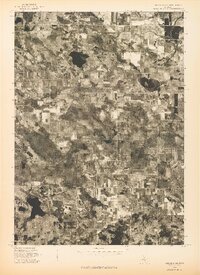
1976 Map of Hersperia NE
USGS Topo · Published 1976About this map
Walkerville serves as the primary hub in this agricultural and wooded corner of Oceana County, captured during the spring of 1976. This orthophotoquad provides a clear aerial view of the geometric field patterns and dense woodlots that define the West Michigan interior. The landscape is dotted with numerous kettle lakes and wetland depressions, characteristic of the region's glacial geography, showing the distribution of woodlots and drainage patterns as they existed in the mid-1970s. For those researching local land use or property boundaries, the map offers an unfiltered look at the rural road grid and the footprint of the Walkerville settlement before modern development altered the rural character of the township.
Find a feature on this map
1 named feature on this map. Tap any name to fly to it.
Don’t see what you’re looking for? This feature index may not catch every label — zoom into the map to look around manually.
Map Details
Editions of this 1976 Hersperia NE Map
This is the sole edition of this map. No revisions or reprints were ever made.
Other maps of this area

1931 · Custer SW
USGS Topo · 1:31,680

1931 · Walkerville NE
USGS Topo · 1:31,680

1931 · Walkerville SW
USGS Topo · 1:31,680

1931 · Walkerville NW
USGS Topo · 1:31,680

1931 · Custer SE
USGS Topo · 1:31,680

1931 · Walkerville SE
USGS Topo · 1:31,680

1954 · Milwaukee
USGS Topo · 1:250,000

1954 · Midland
USGS Topo · 1:250,000

1958 · Midland
USGS Topo · 1:250,000

1958 · Milwaukee
USGS Topo · 1:250,000