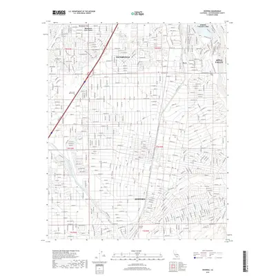
2018 Map of Hesperia
USGS Topo · Published 2018About this map
Victorville and Hesperia anchor this modern landscape at the edge of the High Desert, showing the dense residential growth and industrial infrastructure typical of San Bernardino County in the 21st century. The map traces the critical water management systems of the region, specifically the Governor Edmund G Brown East Branch California Aqueduct, which cuts through the southern portion of the quadrangle. This engineered waterway runs parallel to the natural course of the Mojave River, illustrating the complex relationship between natural hydrology and the man-made systems required to support the expanding populations of Apple Valley and Spring Valley Lake.
Find a feature on this map
334 named features on this map. Tap any name to fly to it.
Don’t see what you’re looking for? This feature index may not catch every label — zoom into the map to look around manually.
Map Details
Editions of this 2018 Hesperia Map
This is the sole edition of this map. No revisions or reprints were ever made.
Other maps of this area

1901 · Southern California Sheet No. 1
USGS Topo · 1:250,000

1902 · Deep Creek
USGS Topo · 1:62,500

1902 · Hesperia
USGS Topo · 1:62,500

1904 · Southern California Sheet No. 1
USGS Topo · 1:250,000

1932 · Barstow
USGS Topo · 1:125,000

1934 · Barstow
USGS Topo · 1:125,000

1942 · Hesperia
USGS Topo · 1:62,500

1953 · San Bernardino
USGS Topo · 1:250,000

1956 · San Bernardino
USGS Topo · 1:250,000
1956 · Cajon
USGS Topo · 1:24,000