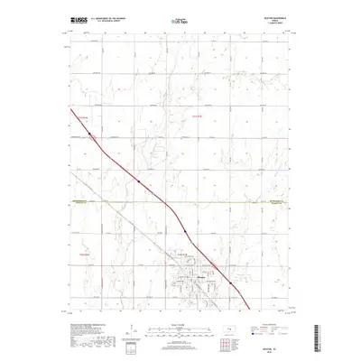
2018 Map of Hesston
USGS Topo · Published 2018About this map
Hesston anchors the southern portion of this landscape, situated at the border of McPherson and Harvey counties. The town's grid expands around Maple Ridge Rd and Dutch Ave, revealing the modern residential and industrial footprint of this Kansas community. North of the town center, the terrain is defined by the drainage of W Emma Cr and Middle Emma Cr, which meander through a strictly organized section-line road network including Cheyenne Rd and Arapaho Rd. A key genealogical landmark, Freedom Cem, sits centrally near Co Rd 451, serving as a silent witness to the area's long-standing rural heritage. The map documents the transition from the concentrated development of the town to the expansive agricultural tracts that stretch toward the northern boundary of the quadrangle.
Find a feature on this map
56 named features on this map. Tap any name to fly to it.
Don’t see what you’re looking for? This feature index may not catch every label — zoom into the map to look around manually.
Map Details
Editions of this 2018 Hesston Map
This is the sole edition of this map. No revisions or reprints were ever made.
Other maps of this area

1889 · Newton
USGS Topo · 1:125,000

1891 · Hutchinson
USGS Topo · 1:125,000

1893 · Hutchinson
USGS Topo · 1:125,000

1894 · Newton
USGS Topo · 1:125,000

1955 · Hutchinson
USGS Topo · 1:250,000

1957 · Newton
USGS Topo · 1:24,000

1959 · Hutchinson
USGS Topo · 1:250,000
1959 · Zimmerdale
USGS Topo · 1:24,000
1959 · Halstead
USGS Topo · 1:24,000

1965 · Goessel
USGS Topo · 1:24,000