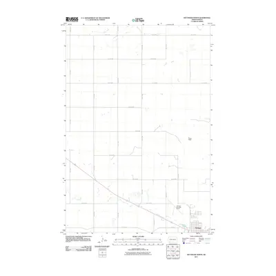
2011 Map of Hettinger North
USGS Topo · Published 2011About this map
Hettinger occupies the southeastern corner of this North Dakota landscape, situated at a transition between the organized grid of the town site and the surrounding Great Plains ranching and farming terrain. The town's proximity to Mirror Lake provides a central landmark, while the Hettinger Municipal Airport serves as a critical transportation hub along Airport Rd. The landscape further north is defined by the high ground of Rocky Ridge and the winding course of Duck Creek, which flows across the northern sections of the township. This 2011 survey documents a rural environment structured by an extensive network of section-line roads, including 9th Ave NW and 1st Ave W, illustrating the persistent agrarian layout of Adams County in the early 21st century.
Find a feature on this map
24 named features on this map. Tap any name to fly to it.
Don’t see what you’re looking for? This feature index may not catch every label — zoom into the map to look around manually.
Map Details
Editions of this 2011 Hettinger North Map
This is the sole edition of this map. No revisions or reprints were ever made.
Other maps of this area

1953 · Dickinson
USGS Topo · 1:250,000

1954 · Lemmon
USGS Topo · 1:250,000

1957 · Dickinson
USGS Topo · 1:250,000

1957 · Lemmon
USGS Topo · 1:250,000

1974 · Hettinger North
USGS Topo · 1:24,000

1974 · Hettinger South
USGS Topo · 1:24,000

1974 · Cow Butte NE
USGS Topo · 1:24,000

1974 · Kid Rich Butte
USGS Topo · 1:24,000

1980 · Mott
USGS Topo · 1:100,000
1984 · Lemmon
USGS Topo · 1:100,000