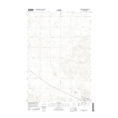
2014 Map of Hettinger North
USGS Topo · Published 2014About this map
Hettinger sits at the southern edge of this West River landscape, serving as a hub where the prairie meets the drainage of Flat Cr. The settlement pattern is defined by a rigid grid of agricultural roads, including Three Mile Rd and various numbered avenues like 9th Ave NW, which carve the North Dakota plains into productive sections. To the north, the elevation rises toward the prominent Rocky Ridge, providing a topographical contrast to the stream valleys. This era of development is marked by the infrastructure of the Hettinger Municipal Airport and the recreational space at Mirror Lake, which borders the main townsite. The drainage of Duck Cr in the northern portion of the quadrangle further illustrates the hydrologic network that supported the region's ranching and farming economy during the early 21st century.
Find a feature on this map
34 named features on this map. Tap any name to fly to it.
Don’t see what you’re looking for? This feature index may not catch every label — zoom into the map to look around manually.
Map Details
Editions of this 2014 Hettinger North Map
This is the sole edition of this map. No revisions or reprints were ever made.
Other maps of this area

1953 · Dickinson
USGS Topo · 1:250,000

1954 · Lemmon
USGS Topo · 1:250,000

1957 · Dickinson
USGS Topo · 1:250,000

1957 · Lemmon
USGS Topo · 1:250,000

1974 · Hettinger North
USGS Topo · 1:24,000

1974 · Hettinger South
USGS Topo · 1:24,000

1974 · Cow Butte NE
USGS Topo · 1:24,000

1974 · Kid Rich Butte
USGS Topo · 1:24,000

1980 · Mott
USGS Topo · 1:100,000
1984 · Lemmon
USGS Topo · 1:100,000