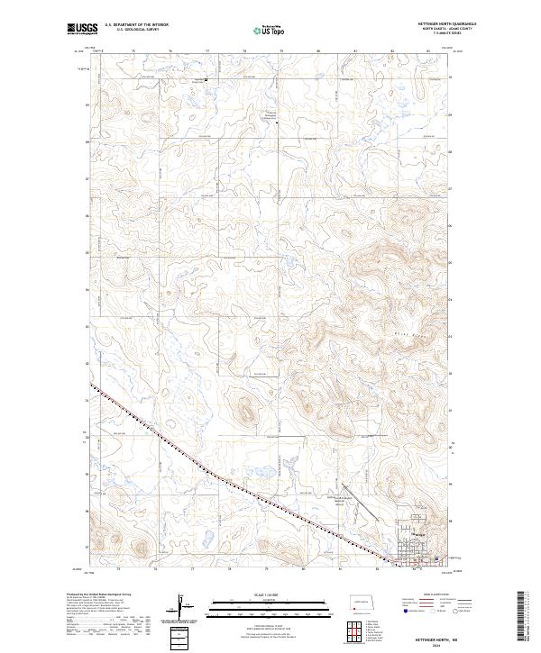
2024 Map of Hettinger North
USGS Topo · Published 2024About this map
The high plains of Adams County meet the northern edge of Hettinger, where the town's grid begins to give way to the expansive agricultural landscape. This survey documents the area's spiritual and social geography through sites like the Highland Prairie Cem and the Immanuel Norwegian Lutheran Cem, reflecting the Scandinavian heritage of early settlers in this region of North Dakota. The Adams County Court House serves as a central landmark within the community, while the Hettinger/JB Lindquist Regional Airport marks the transition to the open country to the north.
Find a feature on this map
33 named features on this map. Tap any name to fly to it.
Don’t see what you’re looking for? This feature index may not catch every label — zoom into the map to look around manually.
Map Details
Editions of this 2024 Hettinger North Map
This is the sole edition of this map. No revisions or reprints were ever made.
Other maps of this area

1953 · Dickinson
USGS Topo · 1:250,000

1954 · Lemmon
USGS Topo · 1:250,000

1957 · Dickinson
USGS Topo · 1:250,000

1957 · Lemmon
USGS Topo · 1:250,000

1974 · Hettinger North
USGS Topo · 1:24,000

1974 · Hettinger South
USGS Topo · 1:24,000

1974 · Cow Butte NE
USGS Topo · 1:24,000

1974 · Kid Rich Butte
USGS Topo · 1:24,000

1980 · Mott
USGS Topo · 1:100,000
1984 · Lemmon
USGS Topo · 1:100,000