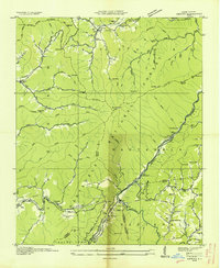
1936 Map of Hewitt
USGS Topo · Published 1936About this map
The Nantahala National Forest dominates this mid-1930s landscape, where the rugged topography of the Cheoah Mountains and The Hog Back dictates the path of early development. Settlements like Stecoah and Hewitt are closely tied to the water and rail corridors, with the Southern Railway winding through the river gorge alongside State Highway No 10. Local industry is evidenced by several sites including a kiln and the Mill Flume, highlighting the era's reliance on timber and mineral resources.
Find a feature on this map
88 named features on this map. Tap any name to fly to it.
Don’t see what you’re looking for? This feature index may not catch every label — zoom into the map to look around manually.
Map Details
Editions of this 1936 Hewitt Map
This is the sole edition of this map. No revisions or reprints were ever made.
Other maps of this area

1933 · Bushnell
USGS Topo · 1:62,500

1935 · Robbinsville
USGS Topo · 1:24,000

1935 · Fontana
USGS Topo · 1:24,000

1935 · Burningtown Bald
USGS Topo · 1:24,000

1935 · Topton
USGS Topo · 1:24,000

1935 · Wayah Bald
USGS Topo · 1:48,000

1935 · Andrews
USGS Topo · 1:24,000

1936 · Proctor
USGS Topo · 1:24,000

1936 · Wesser
USGS Topo · 1:24,000
1936 · Judson
USGS Topo · 1:24,000