
1935 Map of Fontana
USGS Topo · Published 1935About this map
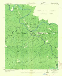
The Little Tennessee River flows through the center of this 1935 advance sheet, marking the boundary between the Great Smoky Mountains National Park and the Nantahala National Forest. Industry and infrastructure are evident in the northern mountains at the Fontana Copper Mine and the Santeetlah Power House, situated before the massive dam projects of the following decade would alter this river valley forever. Local life is documented through scattered mountain schools like Upper Yellow Creek Sch and Rock Spring Sch, while the Southern Railway tracks and State Highway No 288 parallel the riverbanks. Early recreation and regional connectivity are represented by the Appalachian Trail, which winds across the Cheoah Mountains through Wauchecha Bald and Yellow Creek Gap.
Find a feature on this map
44 named features on this map. Tap any name to fly to it.
Don’t see what you’re looking for? This feature index may not catch every label — zoom into the map to look around manually.
Map Details
Editions of this 1935 Fontana Map
This is the sole edition of this map. No revisions or reprints were ever made.
Other maps of this area

1886 · Knoxville
USGS Topo · 1:125,000

1892 · Knoxville
USGS Topo · 1:125,000

1894 · Knoxville
USGS Topo · 1:125,000

1895 · Knoxville
USGS Topo · 1:125,000

1901 · Knoxville
USGS Topo · 1:125,000

1933 · Bushnell
USGS Topo · 1:62,500

1935 · Robbinsville
USGS Topo · 1:24,000

1935 · Calderwood
USGS Topo · 1:24,000

1935 · Santeetlah Creek
USGS Topo · 1:24,000
1935 · Tapoco
USGS Topo · 1:24,000