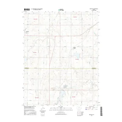
2015 Map of Hiattville
USGS Topo · Published 2015About this map
Hiattville and Pawnee Station anchor this agricultural landscape along the boundary of Bourbon and Crawford Counties. The terrain is defined by a dense network of drainage systems, including the southward-flowing Little Pawnee Cr and Pawnee Cr, alongside Richland Cr and Walnut Cr to the east. A notable geographic feature in the southern portion is Lake Crawford, which serves as a central hydrological point near the Farlington Cem. The map illustrates a strictly organized section-line road grid, featuring thoroughfares such as Cavalry Rd, Birch Rd, and Express Rd. This layout reflects the long-standing rural settlement patterns of southeast Kansas, where small crossroads communities developed to support the surrounding farming and ranching operations during the late twentieth and early twenty-first centuries.
Find a feature on this map
33 named features on this map. Tap any name to fly to it.
Don’t see what you’re looking for? This feature index may not catch every label — zoom into the map to look around manually.
Map Details
Editions of this 2015 Hiattville Map
This is the sole edition of this map. No revisions or reprints were ever made.
Other maps of this area

1884 · Fort Scott
USGS Topo · 1:125,000

1886 · Fort Scott
USGS Topo · 1:125,000

1893 · Fort Scott
USGS Topo · 1:125,000

1947 · Joplin
USGS Topo · 1:250,000

1948 · Mulberry
USGS Topo · 1:62,500

1948 · Girard
USGS Topo · 1:62,500
1949 · Girard
USGS Topo · 1:62,500

1949 · Joplin
USGS Topo · 1:250,000
1950 · Mulberry
USGS Topo · 1:62,500

1954 · Joplin
USGS Topo · 1:250,000