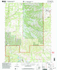
2001 Map of Hiawatha
USGS Topo · Published 2004About this map
Hiawatha and Mohrland anchor the eastern edges of this high-elevation terrain where Carbon and Emery counties meet. The landscape is defined by the massive presence of Gentry Mountain and its radiating ridges, including Gentry Ridge and Wild Horse Ridge. This era of the region’s development is clearly marked by heavy industrial infrastructure supporting coal extraction, with numerous sites such as the Hiawatha Mine, King #3 Mine, and the Blackhawk Mine scattered across the canyons.
Find a feature on this map
62 named features on this map. Tap any name to fly to it.
Don’t see what you’re looking for? This feature index may not catch every label — zoom into the map to look around manually.
Map Details
Editions of this 2001 Hiawatha Map
This is the sole edition of this map. No revisions or reprints were ever made.
Other maps of this area

1885 · Manti
USGS Topo · 1:250,000

1886 · Price River
USGS Topo · 1:250,000

1895 · Manti
USGS Topo · 1:250,000

1896 · Price River
USGS Topo · 1:250,000

1914 · Castle Gate
USGS Topo · 1:62,500

1916 · Castle Gate
USGS Topo · 1:62,500

1923 · Scofield
USGS Topo · 1:62,500

1923 · Hiawatha
USGS Topo · 1:62,500

1925 · Scofield
USGS Topo · 1:62,500

1925 · Hiawatha
USGS Topo · 1:62,500