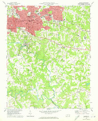
1970 Map of Hickory
USGS Topo · Published 1973About this map
Lenoir Rhyne College serves as a prominent landmark in the northern urban center of Hickory, where the Southern railroad corridor and local textile history shaped the landscape. This 1970 field-checked survey captures the city's southward expansion toward the confluence of the Henry Fork and Jacob Fork, which join to form the South Fk Catawba River. The transition from the dense street grids of Longview and Viewmont to the rolling agricultural and wooded tracts of Startown and Fairbrook is clearly visible.
Find a feature on this map
68 named features on this map. Tap any name to fly to it.
Don’t see what you’re looking for? This feature index may not catch every label — zoom into the map to look around manually.
Map Details
Editions of this 1970 Hickory Map
This is the sole edition of this map. No revisions or reprints were ever made.
Other maps of this area

1895 · Hickory
USGS Topo · 1:125,000

1953 · Charlotte
USGS Topo · 1:250,000

1954 · Charlotte
USGS Topo · 1:250,000

1960 · Charlotte
USGS Topo · 1:250,000

1962 · Charlotte
USGS Topo · 1:250,000
1970 · Banoak
USGS Topo · 1:24,000
1970 · Maiden
USGS Topo · 1:24,000

1970 · Bethlehem
USGS Topo · 1:24,000

1970 · Newton
USGS Topo · 1:24,000
1970 · Granite Falls
USGS Topo · 1:24,000